Do I need to carry Langtang Valley Trek Map?
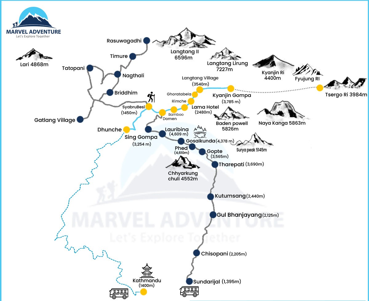
You must include the Langtang Valley Trek map in your packing list. Before starting the journey, studying a map might help you assess the terrain and prepare for the upcoming climb. However, it also can save your life. Knowing how to use the fundamental features of a map can help you navigate the remote trail safely from point A to point B while being grounded and aware of your surroundings.
It is crucial to stay on the correct path when trekking. Going off-the-beaten-track can be risky, particularly in cold terrain where it is simple to get lost. You will never get lost if you have a good sense of direction and can read maps well. You can gain from trekking in many different ways if you have decent map-reading skills.
While climbing in the high mountains, little trekking errors could be fatal. Then, if a bad thing happens while trekking, it will be a significant issue. For instance, your team isolates you, or perhaps one of your teammates vanishes without explanation. At that point, you can assist yourself and your coworkers rather than having to wait hours for assistance. The ability to read a map while trekking could, in the end, save your life and the lives of your teammates.
The trek map shows the separations in elevation and distance between various locations. There are also more details about the walking route, villages, teahouses, lodges, lakes, and other locations.
How to navigate using a map?
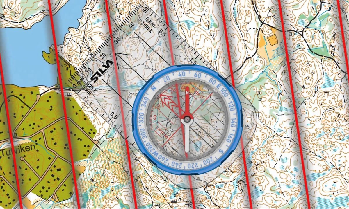 Before beginning the walk, familiarize yourself with the surroundings around the trail with the Langtang Valley trek map. To use a map to find your way, you need to be aware of the following:
Contour lines: These will make it easier for you to determine when areas of the trail involve hiking up a mountain ridge or traversing a dense forest. It also aids in calculating the height gained during a challenging climb.
Compass edge: Using a compass edge, you may determine how far your campground is from the trailhead.
Find reference points: Using the map legend to locate the lookouts, teahouses, and campsites shown on the map can make it easier for you to orient yourself while you are out on the trail. In the long term, it might enable you to save time, money, and effort.
Itinerary
The following itinerary could be followed by navigating the route on the Langtang Valley Trek Map.
Day 1: Arrival in Kathmandu
Kathmandu Altitude: 1380 m
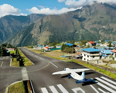
You'll enjoy stunning views of the valley, the Himalayas, and the terraced fields below as you soar toward Kathmandu. After clearing customs, a representative will be there to help you check into your hotel and navigate the initial cultural shock of Kathmandu's twisting, winding streets. After you've settled in, go explore one of Kathmandu's cultural attractions. The evening is a nice time to eat, and Thamel, a popular tourist destination, offers a wide selection of eateries serving both Western and regional Nepali cuisine.
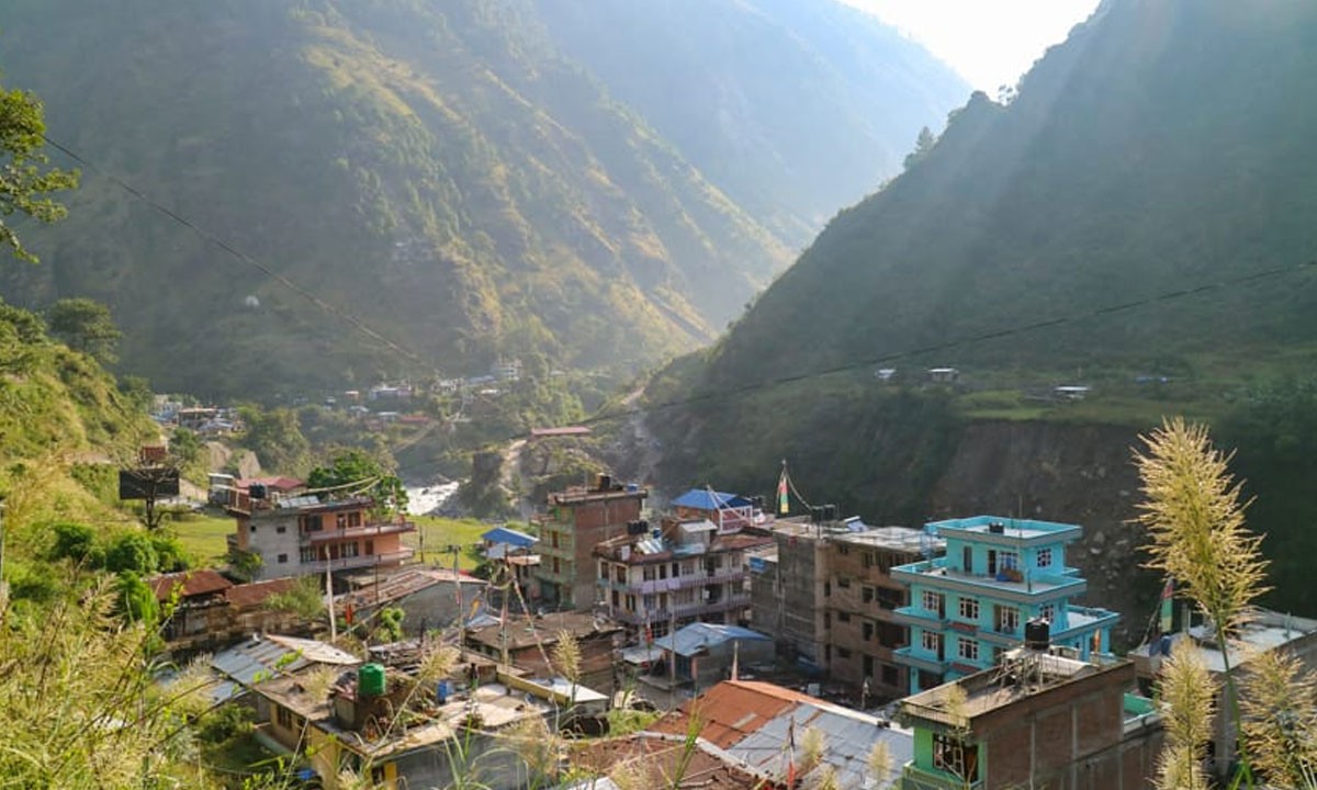
Day 2: Drive from Kathmandu to Syabrubesi
Syabrubensi Altitude: 1450 m
Driving Hours: 7 to 8 hours
Early departure from Kathmandu is advised for the seven-hour trip to the Langtang Valley. As you depart the Kathmandu Valley, the road climbs steeply across slopes and offers breathtaking views of the Annapurna Himalayas in the west, Manaslu, Ganesh Himal, and the peaks of the Langtang region up ahead.
Before ascending to Dunche and the Langtang National Park, we pass through the busy town of Trisuli. After Dunche, it is another hour of downhill travel to reach Syabru Besi and your overnight lodging.
Day 3:Trek to Lama Hotel
Lama Hotel Altitude: 2480 m
Walking Hours: 6 to 7 hours
Walking Distance: 10.9 km
The trail today crosses the Bhote Kosi, also referred to as the "Tibet River," which flows from adjacent Tibet. It then ascends steadily through uninhabited oak and rhododendron forests until connecting with the trail from Syabru Besi. Monitor the trees for langur monkeys. The difficult ascent through the woods to the Lama Hotel is rewarded with a nice lodge and a comfortable bed in the little town.
Day 4:Trek to Langtang
Langtang Village Altitude: 3540 m
Walking Hours: 5 to 6 hours
Walking Distance: 14.8 km
Today's trek from the Lama Hotel to Langtang village is pretty spectacular. You get up early, prepare your gear, eat breakfast, and then start climbing slowly and steeply as you ascend. You walk alongside the Langtang Khola as you travel through hemlock, oak, and maple forests as well as vibrant rhododendron. Additionally, a stunning view of snow-capped peaks, including Mt. Langtang, starts to come into view.
By staying on the path, you can cross a Ghora Tabela pasture at a height of 2992 meters and come to a wood bridge. After eating your lunch, you gently begin a climb that leads to a glacier. Following that, you keep following the trails as they pass by yak pastures and a helipad before shortly ascending through rhododendron trees to reach the Tamang village.
The hamlet of Langtang is then reached after crossing a stream on these trails. This lovely village features flat-roofed Tibetan-style homes with exquisitely carved wooden windows. The fields where turnips, potatoes, barley, etc. are farmed are enclosed by stone walls that encircle the entire town.
Day 5:Trek to Kyangjin Gompa
 Kyanjin Gompa Altitude: 3900 m
Walking Hours: 4 to 5 hours
Walking Distance: 6.8 km
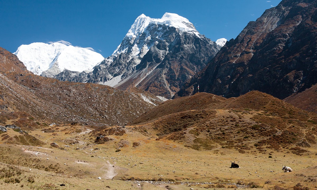
Today, you do the several-hour trek from Langtang to Kyanjin Gompa. You get up, eat breakfast, pack your luggage, and then resume your trip across the Langtang Valley. The walk starts by circling the Mani Walls before ascending a ridge that is crowned by a huge chorten. After passing lovely prayer flags and crossing a stream, you then gradually rise till you reach Mundu at 3543 m.
From this point on, you traverse across numerous moraines and cross several tiny streams using wooden bridges. As you continue walking, you will see Kyanjin Gompa and the breathtaking icefall coming from Kimshug and Langtang Lirung peaks. The last location with tea houses is Kyanjin Gompa, which you reach after more trail walking. You are welcome to visit the stunning and well-known monastery while you are here.
Day 6:Acclimatization Day in Kyangjin Gompa: Hike to Tserko Ri
Tsergo Ri Altitude: 4985 m
Walking Hours: 5 to 6 hours
Today is yours to relax or go exploring. You can go to the cheese factory and the monastery, stroll up the moraine to witness Langtang Lirung's breathtaking ice faces and calving glaciers or climb Kyangjin Ri, which lies right behind the settlement, for an incredible view of the Langtang peaks.
Day 7:Trek to Rimche
Rimche Altitude: 2450 m
Walking Hours: 8 to 9 hours
Walking Distance: 21.6 km
You now make the walk down to Rimche after spending some enjoyable and adventurous time in Kyanjin Gompa. Compared to other days, this day's trip is very lengthy. You first eat breakfast here while taking in the views of the snow-covered peaks before starting the expedition for today.
You return to Langtang village by traveling along the Langtang Khola on the same trail. Following that, you continue traveling and make your way to Ghora Tabela, where you stop for lunch. Following that, you descend steeply to Lama Hotel and proceed a short way before arriving at Rimche. This tiny community, which is split into two halves, is located on the north side of the canyon. This village's east paths link to Sherpagaon.
Day 8:Trek to Syabru Besi
 Syabru Bensi Altitude: 1450 m
Walking Hours: 6 to 7 hours
Walking Distance: 10.9 km
Your adventure across the Langtang Valley is about to conclude. You traverse the paths back to Syabru Bensi today by foot. After a hurried breakfast, you start the hike by going back the same way. Today, most of the routes are downhill and take you through mysterious woodlands, giving you a chance to take in the breathtaking views of the lush hills and mountains.
While traveling through various traditional villages that give you the chance to observe the customs and culture of the ethnic group, you ascend and descend the trails. You finally reach Syabru Bensi after engaging in scenarios and hour-long walks. You can unwind and relish your final night here by going to the natural hot spring.
Day 10:Drive to Kathmandu
Kathmandu Altitude: 1380 m
Driving Hours: 7 to 8 hours
After a leisurely breakfast, we make our way back to Kathmandu. You can take a stroll around Thamel's streets or go last-minute souvenir shopping. In the evening, if you complete the trek, you will receive a complimentary dinner.
Day 11: Final departure
After an incredible 11 days in the Himalayan nation, the tour comes to an official end. You will get dropped off at the airport by our representative. You can then board a flight to your desired destination.
Majpr attraction of Langtang Valley Trek
1. Langtang National Park
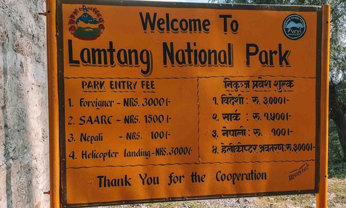 In Nepal's northern region, there is a protected area called Langtang National Park. It was founded in 1976, and its 1,710 square kilometer territory encompasses the Langtang Valley and mountain peaks nearby. Several wildlife species, including red pandas, Himalayan black bears, snow leopards, and musk deer, are found in the region. It also offers a variety of vegetation, from subtropical to alpine woods. The park is a well-liked location for trekkers, and there are many trekking routes accessible, including the Gosaikunda Lake Trek, Tamang Heritage Trail, and Langtang Valley Trek. The Tamang and Sherpa populations, each with its distinct customs, traditions, and language, call this park home, adding to its cultural value.
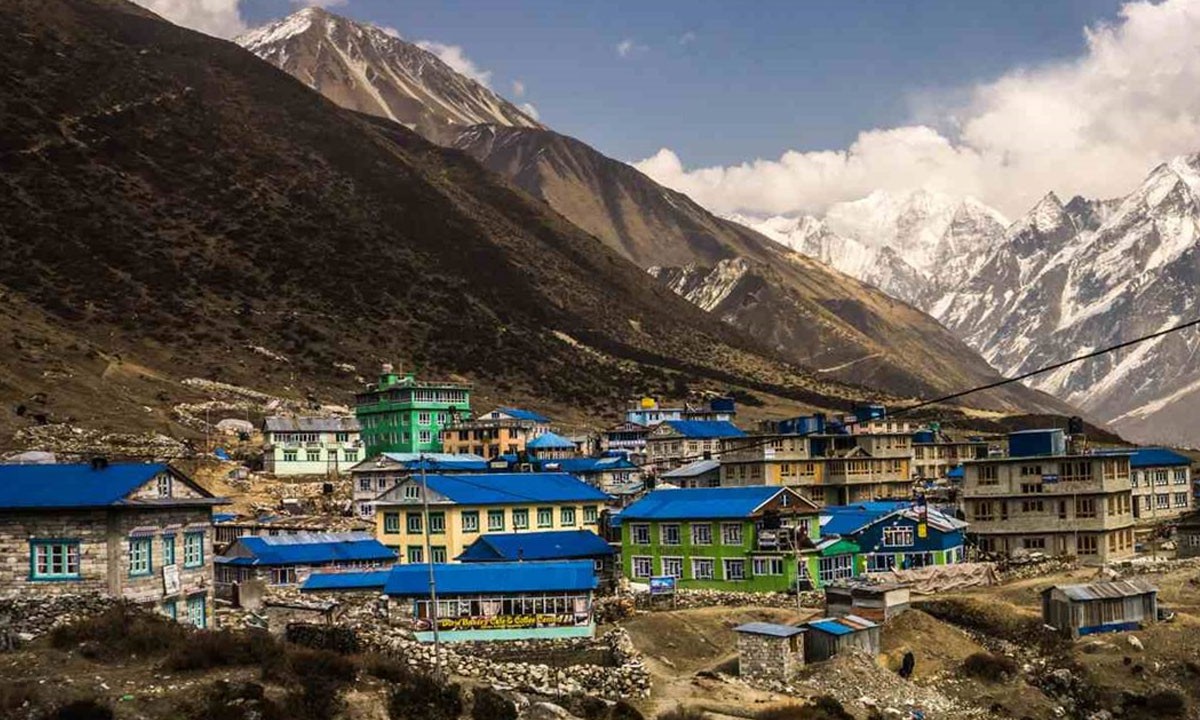
2. Kyanging gompa
Kyanjin Gompa, a small village in Nepal's Langtang area, is well-known among trekkers and hikers for its breathtaking natural beauty and distinctive culture. The settlement is surrounded by snow-capped mountains, including the Langtang Lirung (7,227 meters/23,711 feet), Yala Peak (5,520 meters/18,110 feet), and Naya Kanga (5,844 meters/19,163 feet), and is located at an elevation of 3,800 meters (12,467 feet).
Kyanjin Gompa is renowned for its namesake Buddhist monastery, which is situated in the village's center. One of the most important pilgrimage sites in the Langtang region, the monastery is thought to be older than 400 years. It is a location with immense spiritual value and draws a large number of followers from all over the world.
The tranquil and lovely Kyanjin Gompa offers a rare synthesis of spiritual significance, natural beauty, and cultural depth.
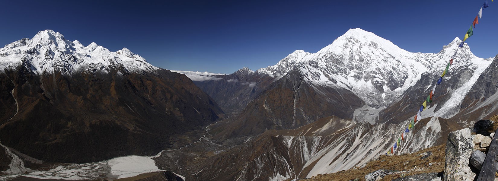
3. Langtang Valley
 In Nepal's Langtang National Park, the Langtang Valley is a well-known place for hiking. The valley, which is about 19 miles to the north of Kathmandu, is renowned for its breathtaking natural beauty, distinct cultural heritage, and abundant biodiversity. Langtang Lirung, Ganesh Himal, and Dorje Lakpa are just a few of the magnificent peaks that can be found in the Langtang region.
Trails through picturesque scenery of luxuriant forests, rivers, waterfalls, and high-altitude meadows may be found in the Langtang Valley. Various uncommon and endangered species can be found in the Langtang National Park, another feature of the area's diversified flora and wildlife. Tamang, Sherpa, and Gurung ethnic communities are among those who call Langtang Valley home. These settlements offer a fascinating glimpse into the region's traditional way of life thanks to their distinctive cultures and lifestyles. The trip is a fantastic way to learn about the local way of life and meet the kind inhabitants.
Nature lovers, trekkers, and adventure seekers should visit the Langtang Valley. It provides guests with a once-in-a-lifetime experience that will last them a lifetime because of its astounding natural beauty, vibrant culture, and biodiversity.
4. Tserko Ri
The peak Tserko Ri is situated in Nepal's Langtang area. It is a mountain range in the Himalayas and is 4,984 meters (16,348 feet) above sea level. In addition to providing breathtaking panoramic views of the nearby peaks, such as Langtang Lirung, Langshisa Ri, Gyanghempo, Dorje Lakpa, and Ganesh Himal, Tserko Ri is a well-known hiking location. The journey to Tserko Ri typically lasts 5–6 days and is renowned for its varied topography, including high-altitude mountains and lush woods. The walk is appropriate for both novice and seasoned hikers, however, due to the high altitude, good acclimatization is required.
5. Gosaikunda Lake
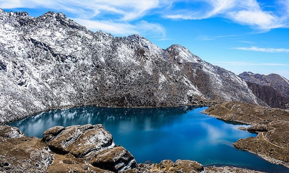 In Nepal's Langtang National Park, there is a high-altitude freshwater lake called Gosainkunda Lake. Both Hindus and Buddhists regard it as a sacred spot, and it is located at a height of 4,380 meters above sea level. The lake is nourished by the melting snow and glaciers of the Langtang range and is surrounded by spectacular snow-capped mountains. According to Hindu legend, Lord Shiva is thought to have carved out Gosainkunda by driving his Trishul (trident) into the mountain to establish a source of water for soothing his thirst. Every year during the Janai Purnima full moon festival, thousands of pilgrims from India and Nepal come to the lake to worship Lord Shiva and take a sacred bath. The lake is also a well-liked location for adventure seekers and provides a beautiful trekking route.
Read also
Conclusion
One of Nepal's most breathtaking short treks is the Langtang Valley expedition. The Langtang region, which borders Tibet and is north of the Kathmandu Valley, is a well-liked trekking destination for both foreign and local tourists from Nepal. Trekkers who wish to explore and get lost in nature on their own might consider the combined Langtang trek, which includes both natural and cultural highlights.
The Langtang Valley Trek Map provides a far more practical method of trekking in the Himalayas. A map should be brought while starting an expedition in the remote Himalayas. You can make your way across challenging trails with its assistance. A map can be used to calculate elevation and trek distance. Additionally, a map might help you get out of the area if you ever get lost there. Grab a Langtang Valley Trek Map, and go off on this breathtaking adventure.