Manaslu and Annapurna Circuit Trek

Duration: 21 Days   |   Trip Photos  |  
  • Destination: Nepal
  • Trip Difficulty: Strenuous
  • Trip Style: Lodge to Lodge Trek
  • Transport: Private Vehicle / Tourist Bus
  • Food: Breakfast + Lunch + Dinner
  • Accommodation: Hotel + Teahouses + Lodges
  • Group Size: Min 2
  • Max Elevation: 5,416 meters

Manaslu and Annapurna Circuit Trek 21 days itinerary

Manaslu and Annapurna Circuit Trek is an incredible expedition that combines two of the mainstream trekking routes of the Himalayan region in a single itinerary. This 20 Day- Manaslu with Annapurna Circuit Trek takes you across scenic landscapes, popular highlights, religious landmarks, and the vibrant traditional high Himalayan settlements of both Manaslu and Annapurna regions. Besides the exploration of the Manaslu Conservation Area and Annapurna Conservation Area, you will also take on two of the fascinating high Himalayan passes, like Larkya La Pass [5,106 meters/ 16,751 feet] and Thorong La Pass [5,416 meters/ 17769 feet] in this expedition.

Following the circumnavigating trails around the eight-highest mountain in the world, Mt. Manaslu [8,163 meters/ 26,781 feet], during the first part of this adventure, you will then move along the exploration of the foothills of the tenth-highest mountain in the world, Mt. Annapurna [8,091 meters/ 26,545 feet]. Manaslu Annapurna Circuit Trek is a remarkable Himalayan adventure if you are looking for an extended adventure to explore the magnificent regions beneath two of the towering massifs in the Himalayas.

Highlights

  • A circumnavigating adventure of the two 8,000-meter class mountains in the Himalayas: Manaslu [8,163 meters/ 26,781 feet] and Annapurna [8,091 meters/ 26,545 feet]
  • Exploration of the diverse flora and fauna of the Manaslu Conservation Area (est 1998) and Annapurna Conservation Area (est 1985)
  • Traversing across two high Himalayan passes, Larkya La Pass and Thorong La Pass
  • Incredible views of the Himalayan peaks like Manaslu, Lamjung, Annapurna, Dhaulagiri, Tukuche, Ganesh Himal, Himchuli and Gangapurna
  • Glacial lakes, deep gorges, Himalayan streams, and charming waterfalls of both naturally flourishing regions
  • Diverse trekking trail passing through the traditional villages of Gurung, Magar, Nubri, and Tsum ethnic group

Day to Day Itinerary

  • Day 1 Drive from Kathmandu to Machhakhola

    Kathmandu Elevation: 1,400 meters/ 4,593 feet

    Machhakhola Elevation: 900 meters/ 2,952 feet

    Elevation Loss: 500 meters/ 1,640 feet

    You will start your Manaslu and Annapurna Circuit Trek on Day 1 with a scenic drive from Kathmandu to Machhakhola. Driving on Prithivi Highway, you will follow the crusading Trishuli and Marshyangdhi Rivers. Proceed further on your driving trails; you will drive past several settlements, lush high hills, fascinating settlements, streams, and waterfalls, enjoying the stunning Himalayan vista on the left corner.

    After crossing the Trishuli River to head toward Dhading Bensi, you will continue toward Arughat, following the Dorandi Khola to the north. Then, from here, moving past the traditional Gurung and Magar settlements at the Sotikhola, you will reach Machhakhola, your resting destination tonight after a long day’s drive.

    Driving Duration: 8-9 hours

    Driving Distance: 160 km

    • Meals: BLD
    • Accommodation: Tea houses/ Lodge
    • Place: Machhakhola
    • Altitude: 900 meters
  • Day 2 Trek from Machhakhola to Jagat

    Machhakhola Elevation: 900 meters/ 2,952 feet

    Jagat Elevation: 1,350 meters/ 4,429 feet

    Elevation Gain: 450 meters/ 1,476 feet

    Commencing the trekking adventure from Day 2 in your Himalayan exploration, you will cross the Tharo Khola during the first part and head upstream to Khola Beni. The route stretching forward across a bridge takes you to the small settlement of Khorlabesi and then onward to Tatopani, the natural hot spring in the area.

    Then, moving forward with this day’s trekking adventure, you will follow the eastern bank of the Budhi Gandaki River and cross a suspension bridge heading toward Doban. From here, you will cross another suspension bridge, over the Yaru Khola to reach the stone stairs of the Thado Bharyang. During the last stretch of this day’s adventure, you will cross the west bank of the Budhi Gandaki River, follow the ridge over the river, and finally arrive at Jagat, the entrance of the Manaslu Conservation Area.

    Trek Duration: 6-7 hours

    Trek Distance: 17 km

    • Meals: BLD
    • Accommodation: Tea houses/ Lodge
    • Place: Jagat
    • Altitude: 1,350 meters
  • Day 3 Trek from Jagat to Deng

    Jagat Elevation: 1,350 meters/ 4,429 feet

    Deng Elevation: 2,130 meters/ 6,988 feet

    Elevation Gain: 780 meters/ 2,559 feet

    After breakfast, moving further ahead with the trekking adventure of this day, you will leave the Jagat behind and follow the ascending trails over the village, heading toward Salleri. The trail further ahead then descends to the Sirdibas village and moves along the wide Budhi Gandaki River Valley, continuing upstream the Ghatta Khola.

    Then, after crossing a suspension bridge over the river, you will push for the large traditional Gurung settlement of Philim. From here, the trail stretches toward the north across the millet fields toward Ekle Bhatti and descends on the grassy slopes to cross the Budhi Gandaki River. Your trekking trail further up ahead goes across the east bank of the river through bamboo forests; then, after passing Pewa, you will shortly arrive at Deng.

    Trek Duration: 6-7 hours

    Trek Distance: 19.9 km

    • Meals: BLD
    • Accommodation: Tea houses/ Lodge
    • Place: Deng
    • Altitude: 2,130 meters
  • Day 4 Trek from Deng to Namrung

    Deng Elevation: 2,130 meters/ 6,988 feet

    Namrung Elevation: 2630 meters/ 8,628 feet

    Elevation Gain: 500 meters/ 1,640 feet

    It’s an exciting day’s trekking adventure in your iconic Himalayan exploration; ascending past the Rana, you will push for the Bhi. Then, moving across the captivating rhododendron, fir, and pine forests, you will head toward Ghap. You will also have the opportunity to enjoy the spectacular views of the Siringi Himal from the Prok Village.

    Proceeding further with your trekking route, you will cross the Budhi Gandaki River several times on this day and trek closer to the Tibetan border. As you get closer to Namrung, you will be able to witness the Tibetan culture-influenced communities and monasteries. This beautiful high-altitude settlement is just 6 km farther from the Tibetan border; the natives of the region speak the Tibetan language and follow Tibetan culture and traditions.

    Trek Duration: 6-7 hours

    Trek Distance: 17 km

    • Meals: BLD
    • Accommodation: Tea houses/ Lodge
    • Place: Namrung
    • Altitude: 2630 meters
  • Day 5 Trek from Namrung to Shyala

    Namrung Elevation: 2630 meters/ 8,628 feet

    Shyala Elevation: 3,543 meters/ 11,624 feet

    Elevation Gain: 913 meters/ 2,995 feet

    It's a short and scenic day’s trekking adventure in your Himalayan exploration; after breakfast, you will trek past the lush landscapes across the rhododendron, fir, and oaks forest heading toward Lihi. Then, moving further in your trekking trail, enjoying the incredible views of Himalayan massifs like Manaslu, Ganesh Himal, and Himchuli, you will arrive at Sho.

    A short trekking distance from the Sho village will then take you to the Lho Village, which is known for its traditional settlements of stone houses and the rich Tibetan-culture-influenced lifestyle of the natives. From here, you will trek for about one and a half hours to reach Shyala Village, your resting destination tonight; this charming high-altitude settlement offers a stunning view of the Ngadi Chuli to the southwest side.

    Trek Duration: 4 hours

    Trek Distance: 13 km

    • Meals: BLD
    • Accommodation: Tea houses/ Lodge
    • Place: Shyala
    • Altitude: 3,543 meters
  • Day 6 Trek from Shyala to Samagaun via Pungyen Monastery

    Shyala Elevation: 3,543 meters/ 11,624 feet

    Samagaun Elevation: 3,500 meters/ 11,482 feet

    Elevation Loss: 43 meters/ 141 feet

    Leaving one of the largest villages in the Manaslu Conservation Area behind, today, after breakfast, you will again traverse across lush pine and rhododendron forest. Enjoying the stunning views of the Manaslu, you will move along the yak pastures on the trail and head toward Pungyen Monastery.

    After reaching the monastery, it is mostly downward trekking, Samagaun is at a distance of just 5km from Pungyen, and you will enjoy trekking on the gradual trail before arriving at the Kani Gate, the entrance point of Samagaun. Along the trekking trail, the spectacular views of Manaslu and Himalchuli will loom on the south side, and meanwhile, the pristine Ganesh Himal greets you on the east side. Enjoying the hospitality of the Nubri inhabitants, you will rest here tonight, enjoying the magical Himalayan ambiance.

    Trek Duration: 5-6 hours

    Trek Distance: 8 km

    • Meals: BLD
    • Accommodation: Tea houses/ Lodge
    • Place: Samagaun
    • Altitude: 3,500 meters
  • Day 7 Acclimatization at Samagaun

    Samagaun Elevation: 3,530 meters/ 11,482 feet

    You will take a break from your Himalayan expedition on this day, as you have gained a significant altitude; today will be a rest day. You will use this day in your Manaslu and Annapurna Trek to acclimatize properly to the rising altitude before proceeding any further.

    Samagaun is a perfect acclimatizing destination with a lot of exploration prospects; you can do hikes to Birendra Tal, or the Manaslu Base Camp [4,800 meters/ 15,748 feet] that are popular among trekkers. In the evening, you can just stroll around the traditional village, exploring the immersive culture and traditions of the natives. Overnight stay at Samagaun.

    • Meals: BLD
    • Accommodation: Tea houses/ Lodge
    • Place: Samagaun
    • Altitude: 3,530 meters
  • Day 8 Trek from Samagaun to Samdo

    Samagaun Elevation: 3,500 meters/ 11,482 feet

    Samdo Elevation: 3,860 meters/ 12,664 feet

    Elevation Gain: 360 meters/ 1,181 feet

    Starting your trek after breakfast on this exciting day’s adventure, you will traverse across the terraced fields and old mani walls as you descend down to the Budhi Gandaki River. Moving further ahead in your trekking trail, you will cross the junction point of the Birendra Tal and the Manaslu Base Camp to reach Kermo Kharka.

    During the last stretch of this day’s trekking adventure, you will cross a wooden bridge over the Budhi Gandaki River and arrive at Kani, the entrance gate of the Samdo Village. You will rest here tonight, enjoying the magnificent views of the Pangpche Peak [6,620 meters/ 21,719 feet] and other adjacent massifs.

    Trek Duration: 3-4 hours

    Trek Distance: 8.2 km

    • Meals: BLD
    • Accommodation: Tea houses/ Lodge
    • Place: Samdo
    • Altitude: 3,860 meters
  • Day 9 Trek from Samdo to Dharamsala

    Samdo Elevation: 3,860 meters/ 12,664 feet

    Dharamsala Elevation: 4,480 meters/ 14,698 feet

    Elevation Gain: 620 meters/ 2,034 feet

    Today, you will head toward Dharmasala, also known as ‘Larkya La Phedi,’ the last resting destination (temporary tent) before Larkya La Pass. During the first leg of this day’s trekking adventure, after breakfast, you traverse across suspension bridges over the Budhi Gandaki River. Then, the ascending trail from here takes you across a bridge, manis walls, and some stone huts along the route before reaching Larkya Bazaar.

    This bazaar used to be an old salt trade hub, where people from all over the valley used to come to buy salt. A short walk from here will take you to Dharamsala; it is not your typical teahouse lodging facility but more of a resting destination for the trekkers in the region. Dharamsala is the highest rest destination in the entire Manaslu Circuit Trek.

    Trek Duration: 4 hours

    Trek Distance: 6.2 km

    • Meals: BLD
    • Accommodation: Tea houses/ Lodge
    • Place: Dharamsala
    • Altitude: 4,480 meters
  • Day 10 Trek from Dharamsala to Bimthang over Larkya La Pass

    Dharamsala Elevation: 4,480 meters/ 14,698 feet

    Larkya La Pass Elevation: 5,106 meters/ 16,751 feet

    Bimthang Elevation: 3,700 meters/ 12,139 feet

    Elevation Gain: 626 meters/ 2,053 feet

    It is an epic day’s trekking adventure today, as this day’s journey will take you across one of the highest Himalayan passes, Larkya La Pass. After breakfast, you will follow the ascending trail to reach the north side of the Larkya Glacier; then, you will continue your trek across the glacial moraines to reach the Larkya La Pass. You will cover an approximate distance of 7.1 km to reach the top of the pass; moving slowly on the steep section of the pass, you will reach the top. From here, you will catch incredible views of the Himalayan peaks like Manaslu, Naike Peak, Pangboche Peak, Larkya Peak, Annapurna II, Kusum Kanguru, and Himlung Himal.

    After releasing the magical ambiance of the mystic Himalayas from the top of the pass, you will begin your descent to the west toward a grassy moraine. First, you will reach Bhimthakoti [3,942 meters/ 12,933 feet] during your descent, which is at a distance of 6.9 km from the top of the pass. Then, trekking across a small meadow, you will head down to a wide open meadow and enter the treeline sections, from here, the trail stretches all the way to Bimthang, past an old mani wall and a small rest house. You will trek about 3 km to reach Bimthang from Bhimthakoti, your resting destination tonight.

    Trek Duration: 8-9 hours

    Trek Distance: 17 km

    • Meals: BLD
    • Accommodation: Tea houses/ Lodge
    • Place: Bimthang
    • Altitude: 3,700 meters
  • Day 11 Trek from Bimthang to Dharapani

    Bimthang Elevation: 3,700 meters/ 12,139 feet

    Dharapani Elevation: 1,860 meters/ 6,102 feet

    Elevation Loss: 1,840 meters/ 6,036 feet

    Proceeding further with your descending trail after completing the exploration of the Manaslu region, you will make your descent to Surki Khola during the first leg. Then, proceeding further in this day’s trekking adventure, you will descend to the Dudh Khola and Soti Khola, heading toward the Gho Village. Then, you will move further ahead across the terraced farmlands and lush forested areas on the north bank of the Dudh Kholka to reach the Gurung village of Tilije.

    From here, you will continue descending further to reach Thonje, and during the final leg of this day’s trek, you will cross a suspension bridge over the Marsyangdi River to reach Dharapani. Overnight stay at Dharapani.

    Trek Duration: 7-8 hours

    Trek Distance: 23 km

    • Meals: BLD
    • Accommodation: Tea houses/ Lodge
    • Place: Dharapani
    • Altitude: 1,860 meters
  • Day 12 Trek from Dharapani to Chame

    Dharapani Elevation: 1,860 meters/ 6,102 feet

    Chame Elevation: 2,670 meters/ 8,759 feet

    Elevation Gain: 810 meters/ 2,657 feet

    Moving further with the second part of your iconic Himalayan exploration in your Manaslu with Annapurna Circuit Trek, on this day, you will follow the lush pine, fir, oak, and rhododendron forests to reach Danakyu Village during the first leg. In this day’s scenic trekking trail alongside the Marsyangdi River, you will be accompanied by spectacular peaks in the Himalayas, like Lamjung Himal, Annapurna II, and other adjacent peaks.

    Following the steep climbing section up ahead, you will then make your way to the Timang Village. Chame, the headquarters of the Manang district, is just at a short walking distance from Timing on the gradual route. You can visit the natural hot spring on the banks of the Marsyangdhi River after your arrival at Chame before turning in for the night.

    Trek Duration: 5-6 hours

    Trek Distance: 15.7 km

    • Meals: BLD
    • Accommodation: Tea houses/ Lodge
    • Place: Chame
    • Altitude: 2,670 meters
  • Day 13 Trek from Chame to Upper Pisang

    Chame Elevation: 2,670 meters/ 8,759 feet

    Upper Pisang Elevation: 3,250 meters/ 10,662 feet

    Elevation Gain: 580 meters/ 1,902 feet

    After breakfast, you will continue your trek alongside the Marsyangdi River on its northern bank. Moving further ahead in your trekking trail, you will pass the Paungda Danda Rock, 1,500 meters (4,921 feet) above the Marsyangdi River, before you follow the steep ascend through the lush pine forest to reach the top of the ridge.

    As you continue forward in this day’s trekking adventure, It will take about 2 hours for you to reach the Bhratang Village. Along the route, the spectacular views of the Lamjung, Pisang, and Annapurna peaks will accompany your adventure on this day. Then, after you cross the Dikur Pokhari, your trekking trail further ahead descends to the floor of the Manang Valley, and you will shortly reach Lower Pisang. From here, you will climb about 50 meters on the other side of the river to reach your resting destination tonight, Upper Pisang.

    Trek Duration: 5-6 hours

    Trek Distance: 14 km

    • Meals: BLD
    • Accommodation: Tea houses/ Lodge
    • Place: Upper Pisang
    • Altitude: 3,250 meters
  • Day 14 Trek from Upper Pisang to Manang

    Upper Pisang Elevation: 3,250 meters/ 10,662 feet

    Manang Elevation: 3,519 meters/ 11,545 feet

    Elevation Gain: 269 meters/ 882 feet

    On this day, you will ascend further toward the heart of the Annapurna region. You will follow the ascending route alongside a river to the northwest and enter a pine forest; moving past the Green Lake in the middle of the forest, you will make your way to Ghyaru. This high-altitude village offers astonishing views of Annapurna II, III, and IV, Tilicho Peak, Pisang Peak, and Gangapurna.

    Proceeding further in this day’s trekking route, you will traverse past the Tibetan settlements and spiritual trails with chortens and praying flags. Then, you will make your way to Ngawal Village [3,660 meters/ 12,007 feet], which is at a trekking distance of 2 hours from Ghyaru. From here, a short trekking distance will take you to Manang; on the trail, you will also get the opportunity to explore the largest monastery in the region, Braga Monastery.

    Trek Duration: 6-7 hours

    Trek Distance: 19 km

    • Meals: BLD
    • Accommodation: Tea houses/ Lodge
    • Place: Manang
    • Altitude: 3,519 meters
  • Day 15 Exploration and acclimatization day at Manang

    Manang Elevation: 3,519 meters/ 11,545 feet

    This will be the second acclimatization day in your Manaslu Annapurna Circuit Trek itinerary; you will use this day to explore the vibrant settlement of Manang and acclimatize properly to the rising altitude. For an effective acclimatization process, you can do some short hikes to Ice Lake and Gangapurna Lake, which are popular among trekkers.

    You can also visit the Himalayan Rescue Association at Vraja Village or just stroll around the beautiful village, checking out this fascinating high-altitude tourist destination. Overnight stay at Manang.

    • Meals: BLD
    • Accommodation: Tea houses/ Lodge
    • Place: Manang
    • Altitude: 3,519 meters
  • Day 16 Trek from Manang to Yak Kharka

    Manang Elevation: 3,519 meters/ 11,545 feet

    Yak Kharka Elevation: 4,120 meters/ 13,517 feet

    Elevation Gain: 601 meters/ 1,971 feet

    After acclimatizing properly to the rising altitude, you will proceed further with your inclining route. During the first part of this day’s trek, you will cross a stream ascending toward the Tenki Village. On this day, you will leave behind the Marsyandgi Valley and head north, pushing for the Jar Sang Khola Valley.

    Then, traversing across the yak pasture and juniper forests, you will make your way toward the Gunsan Village. Ascending trail stretching ahead of this village across a wooden bridge then takes you to the wide, peaceful meadow of the Yak Kharka.

    Trek Duration: 4-5 hours

    Trek Distance: 9.5 km

    • Meals: BLD
    • Accommodation: Tea houses/ Lodge
    • Place: Yak Kharka
    • Altitude: 4,120 meters
  • Day 17 Trek from Yak Kharka to Thorong Phedi

    Yak Kharka Elevation: 4,120 meters/ 13,517 feet

    Thorong Phedi Elevation: 4,560 meters/ 14,960 feet

    Elevation Gain: 440 meters/ 1,443 feet

    After breakfast, you will leave Yak Kharka behind and follow the ascending route, crossing a wooden bridge over the Marsyangdi River to reach Ledar Village. Trekking further ahead, you will move along the east bank of the Jarang Khola and switch to the narrow trail across a narrow slope that descends to Thorong Phedi.

    Thorong Phedi is the last Himalayan village before the Thorong La Pass, and from its vantage point, you will be able to enjoy the rewarding views of the Himalayan peaks like Chulu East, Chulu West, and other adjacent peaks from here.

    Trek Duration: 3-4 hours

    Trek Distance: 7.3 km

    • Meals: BLD
    • Accommodation: Tea houses/ Lodge
    • Place: Thorong Phedi
    • Altitude: 4,560 meters
  • Day 18 Trek from Thorong Phedi to Muktinath via Thorong La Pass

    Thorong Phedi Elevation: 4,560 meters/ 14,960 feet

    Thorong La Pass Elevation: 5,416 meters/ 17769 feet

    Muktinath Elevation: 3,760 meters/ 12.335 feet

    Elevation Gain: 856 meters/ 2,808 feet

    Today, you will take on another high Himalayan pass of this expedition, Thorong La Pass. Following the ascending ridge from Thorong Phedi, you will proceed to the eastern climbing route of the pass. Although it is a slightly tiring day’s adventure, the incredible and refreshing views of the Himalayan gems like Annapurna, Gangapurna, Dhaulagiri, Khatungkang, and other adjacent peaks will help you forget your tiresome journey.

    After enjoying the views from the top of this pass, you will then follow the descending trail toward Muktinath from the west side of the pass. Muktinath is a significant religious site for both Hindus and Buddhists; there are 108 stone taps inside the temple flowing from the Kaligandaki River and an eternal flame that has been burning continuously for more than 2,000 years.

    Trek Duration: 6-7 hours

    Trek Distance: 14.5 km

    • Meals: BLD
    • Accommodation: Tea houses/ Lodge
    • Place: Muktinath
    • Altitude: 3,760 meters
  • Day 19 Muktinath to Tatopani Drive

    Muktinath Elevation: 3,760 meters/ 12.335 feet

    Tatopani Elevation: 1,190 meters/ 3,904 feet

    Elevation Loss: 2,570 meters/ 8,431 feet

    After immersing in the spiritual vibration of this religious site, you will proceed toward your descending journey. Boarding in a comfortable vehicle after breakfast, you will drive past some of the deepest gorges, scenic landscapes, and lush forests, and across the charming Himalayan settlements like Ghasa, Marpha, and Jomsom to reach Tatopani.

    This vibrant settlement in the Annapurna region is famous for its natural hot spring with healing properties. You can take a dip here and relax after a long day’s drive to end this day’s adventure on a high note.

    Drive Duration: 6-7 hours

    Drive Distance: 71 km

    • Meals: BLD
    • Accommodation: Tea houses/ Lodge
    • Place: Tatopani
    • Altitude: 1,190 meters
  • Day 20 Drive from Tatopani to Pokhara

    Tatopani Elevation: 1,190 meters/ 3,904 feet

    Pokhara Elevation: 820 meters/ 2,690 feet

    Elevation Loss: 370 meters/ 1,213 feet

    Bidding farewell to the Himalayan region, today, you will make your descent to Pokhara. Following the trails alongside the Kali Gandaki River, you will drive past the terraced farmlands, lush forests, and beautiful traditional settlements along the way before reaching Pokhara.

    After arriving at Pokhara, you can get some rest and do some sightseeing exploration around this bustling tourist hub. This will be the first day back to modern urbanization after a long Himalayan journey, so you will have plenty of opportunities to explore the top-tier restaurants, cafes, and bars. Tonight, you will rest comfortably in a star hotel, enjoying the luxurious amenities.

    Drive Duration: 5-6 hours

    Drive Distance: 105 km

    • Meals: BLD
    • Accommodation: Hotel
    • Place: Pokhara
    • Altitude: 820 meters
  • Day 21 Drive back to Kathmandu on a tourist bus

    Pokhara Elevation: 820 meters/ 2,690 feet

    Kathmandu Elevation: 1,400 meters/ 4,593 feet

    Elevation Gain: 580 meters/ 1,902 feet

    It is time to wrap up your remarkable expedition in the Himalayas; this day will officially mark the end of your remarkable Himalayan exploration. After eating breakfast, you will board a comfortable tourist bus. You will rejoin the soaring Marsyangdi River and Trishuli River along your driving trail as you drive past the dense forest, beautiful settlements, high hills, and charming streams and waterfalls as you make your way back to Kathmandu.

    After arriving in Kathmandu, you will be dropped back at your respective hotels; you can use the rest of the day to check out the cafes- restaurants or do some sightseeing of the nearby landmarks. Thank you for trekking with Marvel Adventure; we hope to see you again. Have a safe journey!

    Drive Duration: 8-9 hours

    Drive Distance: 204 km

    • Accommodation: Hotel
    • Place: Kathmandu
    • Altitude: 1400m

What to Expect

  • Airport pick-up and drop by private vehicle
  • Government license holder guide 
  • Strong and helpful porter with proper equipment (1 porter for 2 people)
  • Salary, food, accommodation and insurance for guide and porter
  • 1 night Hotel in Pokhara with breakfast
  • Tea house/lodge accommodation during the trek
  • Standard meals (breakfast, lunch and dinner) during the trek
  • Fresh fruits every night after dinner
  • All land transportation as per itinerary
  • TIMS (Trekking Information Management System) card
  • ACAP and MCAP entry permits
  • Manaslu Restricted Area Permit
  • Comprehensive first aid kit with oximeter to measure your oxygen level daily
  • All government taxes and official expenses
  • Duffel bag, sleeping bag, down jacket and walking poles for the trek
  • International airfare and taxes
  • Nepal entry visa fee
  • Your Travel Insurance (compulsory)
  • All the expenses of a personal nature
  • Any kind of drinks and desserts during the trek
  • Hotel in Kathmandu
  • Tips to guide and porter (Tipping is expected)

PRICES & DATES

Trip DatesAvailabilityPrice  
29 Apr, 2024 - 19 May, 2024GuaranteedUSD 1995
Request a Private Date

Useful Information

Best Time for Manaslu and Annapurna Circuit Trek

Best Time for Manaslu and Annapurna Circuit Trek

The peak seasons, like autumn (September to November) and spring (March to May), are known as the best seasons for Himalayan. For the best value Manaslu and Annapurna Circuit Trek experience, we recommend these peak seasons that have the most suitable weather conditions, warm temperatures, flourishing trekking trails, and clear days to enjoy the incredible views of the Himalayan vistas.

Even among the peak seasons, autumn and spring are known for their distinctive features; autumn is generally known for its stable climate and mild temperatures, perfect for outdoor adventures. Whereas, spring is popular for its naturally enthralling trekking trails covered with dotted flowers of the blooming season. The stunning visuals of both the fall and blooming seasons are quite admirable if you are planning to do this trek.

You can expect the temperature of the Manaslu and Annapurna regions to average around 14°C to 18°C during the autumn season and can spike up to 23°C during the spring season. The temperature of both regions is generally in minus degrees at alpine altitude (above 4,000 meters), so make sure to pack accordingly for your Manaslu and Annapurna Circuit Trek.

Is Manaslu and Annapurna Circuit Trek Hard?

Training and Preparation for Manaslu Annapurna circuit trek

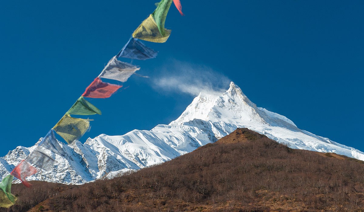
Manaslu Annapurna Circuit Trek is a unique combination of the two mainstream trekking regions in the country. This exhilarating Himalayan expedition takes you across the remote high-altitude regions of both Manaslu and Annapurna region, so it may seem like a demanding exploration. However, this iconic Himalayan expedition is a ‘moderately difficult’ trekking adventure that explores rugged but simple trekking routes.

You don’t have to overcome any technically demanding sections during this trekking expedition and don’t need to have any kind of prior trekking experience to do this trek. With a good health condition, basic fitness level, and adequate preparation, you will be able to easily complete this exhilarating extensive Himalayan expedition. The success rate of Manaslu and Annapurna Circuit Trek is 98% to 100%; it is a slow-paced adventure with enough acclimatization day for you to enjoy a comfortable and memorable Himalayan adventure. So, with the right amount of preparation and determination, you will be able to complete this expedition easily.

Training and Preparation

Is Manaslu and Annapurna Circuit Trek Hard?

To make your Manaslu and Annapurna Trek a remarkable and treasured adventure, you shouldn’t slack out on the preparation part. The general recommended preparation period for this trekking adventure is around 3-6 weeks. However, if you are physically active and have previous high-altitude trekking experience, you may not have to put in too many hours for your preparation part. However, in case, if you are not that physically active and don’t have any prior high-altitude trekking experience, you should put in a few more hours for a comfortable experience.

Generally, your Manaslu Annapurna Circuit Trek takes you across the remote part of the Himalayas with many steep sections, so, you should emphasize your leg muscles to handle the long days of trekking (trekking duration of 6-7 hours on average). You will be carrying your backpack all the way throughout the trek, which can be a little vexing at the high altitudes; thus, focussing on strength and endurance training should be your next priority. Here are some exercises that you can include in your training program during your preparation for the Manaslu and Annapurna Circuit Trek.

Strength and Endurance Exercise: Push-ups, pull-ups, weightlifting, deadlifts, bicep curls, dips, lateral raises, calf raise, squat, lunges, leg press, leg curl, etc.

Cardiovascular Exercises: Jogging, cycling, swimming, dancing, rope jumping, rowing, jumping jack, lateral shuffle, aerobics, burpee, etc.

Read this next:

Send an Enquiry - Manaslu and Annapurna Circuit Trek