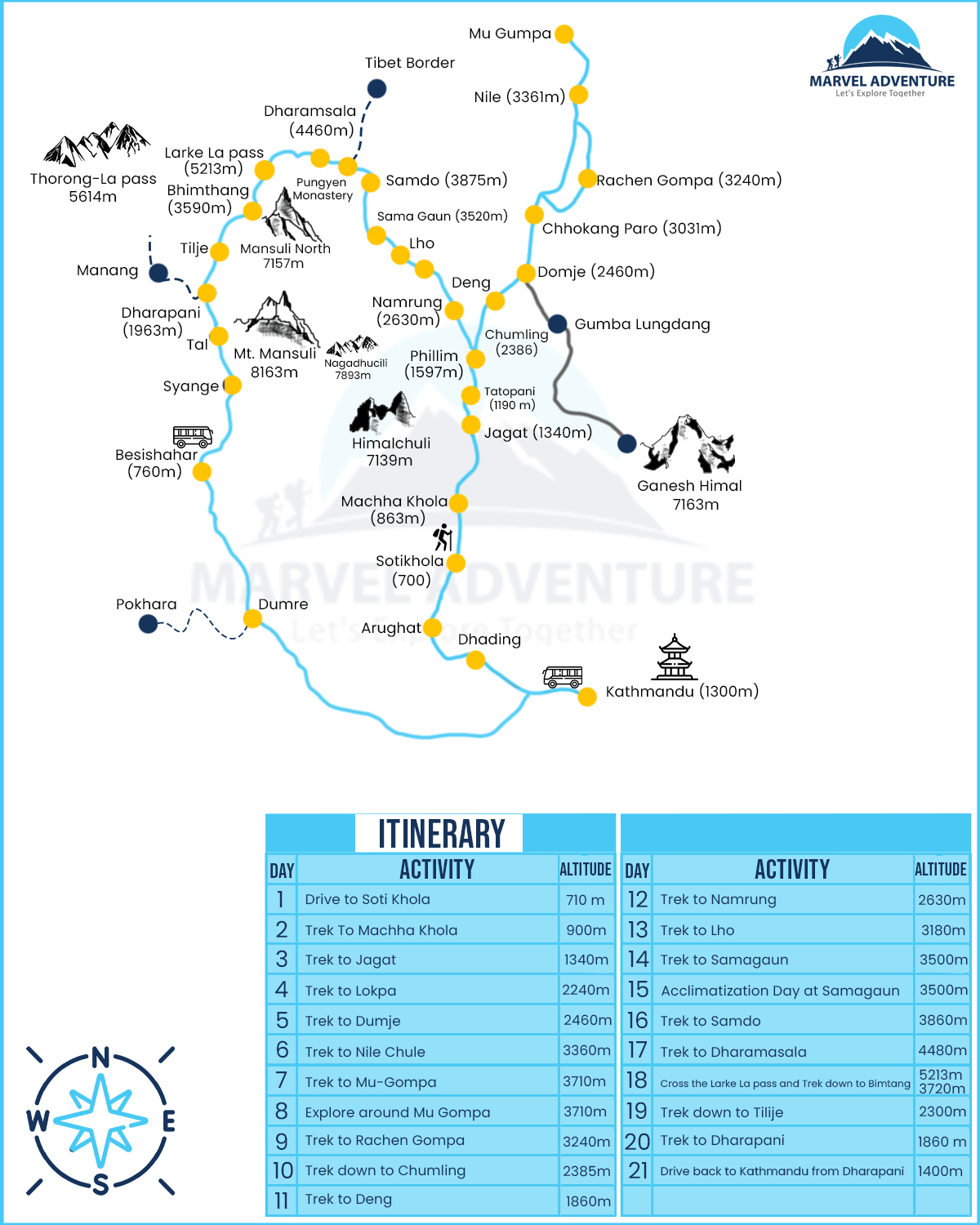
Manaslu Tsum valley trek Map details based on itinerary
Drive from Kathmandu to Soti Khola
Day: 1
Distance: 137 kilometers
Travel time: 5 hours
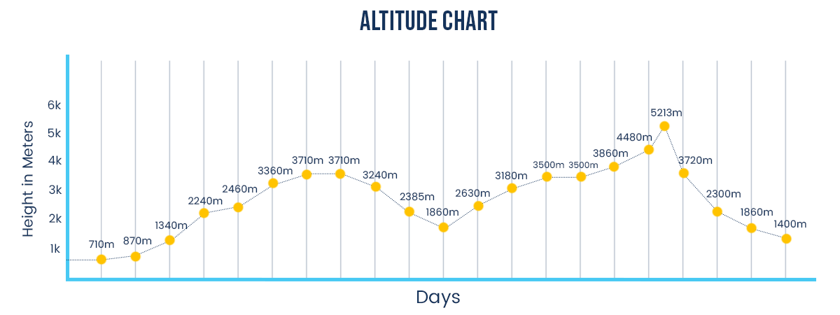
Highest altitude: 710 meters
You’ll begin the day right after breakfast. After a few hours of boarding your vehicle, you will enjoy the views of the rocky terrain, terraces, fields, and rivers on the good, paved route between Kathmandu and Dhadingbesi. Due to the rocky terrain, the trip from Dhading Besi to Arughat is rough. From Arughat, it will take another two hours to get to Soti Khola, where you'll spend your first night at a local lodge.
Trek from Soti Khola to Machha Khola
Day: 2
Distance: 9.7 kilometers
Highest altitude: 870 meters
Trekking hours: 4 to 5 hours
After breakfast, you will leave for Machha Khola. The trail gently ascends through lovely Sal forests. Later, it descends to pass through rice paddies before ascending to the lovely Gurung village of Labubesi (885m). The trail descends onto gravel banks along the river before rising slightly to the village of Machha Khola after crossing a suspension bridge at the Nauli Khola Falls.
Trek from Macha Khola to Jagat
Day: 3
Distance: 50.1 kilometers
Highest altitude:885 meters
Trekking hours: 7 to 8 hours
The trail ascends and descends mountains while following the Budhi Gandaki River. You will go to the villages of Tatopani and Khorlabesi. You then have to cross the bridge to the Budhi Gandaki's east side and proceed through the forest to Dobhan. Down the trail, cross the Yaru Khola River Bridge. After navigating another bridge over the Budhi Gandaki, you will finally reach Jagat village.
Trek from Jagat to Lokpa
Day:4
Distance: 49.2 kilometers
Highest altitude: 2040 meters
Trekking hours:6 to 7 hours
You will have to cross a bridge over the Dudh Pokhari Khola after passing through Jagat. Then you will travel through the towns of Sirdibas and Salleri. The trail then descends to the larger town of Philim, where it uses a bridge to cross the Buri Gandaki. Before we enter Tsum Valley, the authorities check our permits at a checkpoint at Philim. Then, you continue travelling towards Lokpa
Trek from Lokpa to Dumje
Day - 5
Highest altitude:2460 meters
Trekking hours:5 to 6 hours
You'll proceed to Ganesh Himal Base Camp from Lokpa by taking the trail that ascends and crosses a ridge before continuing to Chumling. On the southern side of Shingri Himal is Chumling, also referred to as lower Tsum. Continue traveling for a few more hours until you arrive in Dumje.
Trek from Dumje to Nile Chule
Day-6
Highest altitude: 3360 meters
Trekking hours: 6 to 7 hours
After breakfast, you will set out on a 7-hour trek to Chule. Before reaching the Upper Tsum Valley from the north, this is the last town. About a 20-minute walk from Chule, on the west bank of the Shiar Khola, is where you'll find the Nile. The Piren Phu cave, which is close to Burji Village at the base of a rocky cliff, is a stop-off point on the way to Tsum. You will see a breathtaking view of the nearby Shiar Khola, Rachen Gompa, mountains, and farming plains.
Trek from Nile Chule to Mu Gompa
Day- 7 and 8
Distance:7.9 kilometers
Highest altitude: 3710 meters
Trekking hours: 4 to 5 hours
You will ascend to Mu Gompa on foot and tour the monastery. Nearly 3,700 meters above sea level, Mu Gompa is encircled by mighty mountains. Additionally, it is the largest monastery in the area. The trek will last about 4 hours, which is not very long but exciting.
You will spend the next day of the trek here as well. You will tour Mu Gompa and its surroundings all day long. The day's main highlights will include scaling minor peaks, arriving at Pika Himal's base, and taking in breathtaking views of Tibet and Tibetan peaks.
.jpg)
Trek from Mu Gompa to Rachen Gompa
Day- 9
Highest altitude: 3240 meters
Trekking hours:4 to 5 hours
Staying on the east side of the Sitar Khola, you will continue on our journey by negotiating the flat stones that lead to RachenGompa. Visit a historic gompa and tour the neighborhood of gompa families. The family includes at least one monk or nun.
Trek from Rachen Gompa down to Chumling
Day- 10
Highest altitude: 2386 meters
Trekking hours: 6 hours
You will now descend in the direction of Chumling after crossing the river and passing through Chhokang Paro. After two hours of walking, we reach Siyar Khola after passing a white monastery. The abundance of water here makes it a spot to wash clothes. For the night, you will stop at Chumling.
Trek from Chumling to Deng
Day- 11
Highest altitude:1860 meters
Trekking hours: 4 to 5 hours
You will have to make the exhausting journey back from Chumling to Lokpa, after which you can simply descend through the forest and rejoin the main Manaslu Circuit trail to get to Deng. The main trail winds through the narrow Budhi Gandaki gorge, crossing the river on numerous lengthy suspension bridges.
Trek from Deng to Namrung
Day- 12
Distance: 19.5 kilometers
Highest altitude:2630 meters
Trekking hours: 6 to 7 hours
Continuing with the route, you can take the main trail to Bihi Phedi or a slightly longer route up to Bihi Village. It is an ordinary town off the Manaslu Circuit trail that doesn't appear to see many hikers due to the lack of lodges. After leaving the village, you will return to the main trail and continue on to Ghap for lunch after a steep descent.
The Budhi Gandaki valley widens after Ghap. You will eventually cross a suspension bridge over a river where you can see the Budhi Gandaki squeezed beneath a naturally occurring stone arch. After that, Namrung is reached after a steady ascent up a magnificent stone staircase. Although you might not expect it, you will see a very fashionable, fancy-looking, and pricey hotel in Namrung
Trek to Lho from Narmung
Day - 13
Distance: 11 kilometers
Highest altitude: 3180 meters
Trekking hours: 6 to 7 hours
You will return from Namrung to an area that is influenced by Buddhism and probably ascend to a higher altitude. You will have to trek for about half a day to Lho before reaching the Sho settlement, which is known for its apples, with stunning views of Himalchuli at the summit of Hinang Glacier.
You'll walk up to the impressive-looking Ribung Monastery in the late afternoon and ascend the hill behind it to get a clear view of the Manaslu Massif. You can also ascend a short distance from the hotel to a well-liked vantage point close to Ribung Monastery to observe the mesmerizing sunlight rays on Manaslu.
Trek from Lho to Samagaun
Day- 14 and 15
Distance:17.2 kilometers
Highest altitude: 3500 meters
Trekking hours: 5 to 6 hours
Once again, you will have an easy half-day walk to Samagaon, where you can capture yet another iconic image of Manaslu with a Chorten in front of it near Lho. The trail descends to a river and then climbs back up. The ascent ends at the village of Shyala, then the valley begins to open up, and the trail becomes a simple stroll through the grasslands.
The Shyala village will give you stunning views of Himalchuli, Nadi Chul, and other nearby peaks. You can also see Manaslu, Naike peak, Larkya peak, Sambdo, and Saula Himal.
The renowned Sama monastery is located at the far end of the village, looking out over the valley. At the base of Manaslu, in the village of Samagaun, where we will stay, Tibetans make up the majority of the population. The Birendra Tal sightseeing can be done after a short rest. The lake is at about an hour worth of walk from Samagaun.
The Samagaun stay is usually reserved for two days. The first day for arrival and the next for acclimatization. The second day is reserved for relaxation. You will remain in Samagaun and tour the neighborhood.
You can visit the Pungyen Gompa, located at a hill close to Smagaun, which offers a breathtaking view of the glaciers.
You can hike towards the Gompa, which is named after the two peaks of Manaslu. When the Japanese first attempted to summit the peaks, it was destroyed. As per popular beliefs, the ascent to the summit may have incensed the gods. After your trek to the Gompa, you will return to Samagaon and spend the night there, ending the detour.
Trek from Samagaun to Sambo
Day- 16
Distance:16.4 kilometers
Highest altitude:3860 meters
Trekking hours:4 to 5 hours
The trek route will continue along the Budhi Gandaki River until you reach a suspension bridge over a stream. The trail doesn’t have anything extraordinary.It only houses a few small birch, juniper, and larch trees and lots of scrubby bushes, including berberis and rose. There are no fields and no large trees to be found here.
The path continues to follow the river as it gradually ascends through the valley. At the end of the day, the path becomes steeper and leads to the village of Samdo, where you can see Samdo Peak (6335 meters) looming to the east.
Trek from Sambdo to Larkya La Phedi/Larkya La Base Camp/Dharmasala
Day- 17
Highest altitude: 4480 meters
Trekking hours: 4 to 5 hours
The trail briefly descends gradually before beginning to climb toward the Larkya Glacier. The Dharmasala, also known as Larkya la Base camp, is the destination after the path becomes easier. The trek will offer truly stunning views of Samdo Peak, Naike Peak, Larke Peak, Cheo Himal, and Manaslu and Manaslu North.
We have just enough time and space to rest and acclimatize for the remainder of the trek on this quick hike to Larke Phedi.
Trek to Bimthang through the route crossing the Larke La Pass
Day- 18
Distance:24.7 kilometers
Highest altitude: 5213 meters
Trekking hours: 7 to 8 hours
The Larkya Glacier is reached after an early start and a steady ascent. Views of Himlung (7126 meters), Annapurna II (7937 meters), Kang Guru (6981 meters), and several other peaks rising above 6000 meters are available from the summit. Prayer flags will be flying in the wind as you make your way towards Bhimtang along the rough, rocky trail, across the glacial moraine, and with beautiful views of the sunrise on Larke Peak.
As you descend the trail to reach Bimthang(also known and bintang), you first encounter a steep drop on the snow, which is followed by the glacial moraine for the remainder of the day.
Once you reach Bimthang, you can take in lovely views of sunset on Manaslu as well as Phungi Himal, Nadi Chuli, and Cheo Himal. Himlung, Ponkar Peak, and Kang Guru.
Trek from Bimthang down to Tilije
Day-19
Distance: 26.3 kilometers
Highest altitude: 2300 meters
Trekking hours:4 to 5 hours
The route for this day will have a descent. Lush forests welcome you as you turn away from the mountains and proceed to the well-known rhododendron bushes. After crossing the Dudh Khola, you will reach Karche.
You will then pass through remnants of a glacial flood along this trail in the form of small valleys. Although the trail can be quite difficult, it only enhances the beauty of what you've just accomplished on this trek. We will keep descending until we reach the Gurung Goa village.
You will once more be greeted by the lush vegetation of agricultural fields and oak forests as you depart the icy lands. You will continue walking until Tilije, where we will make a stop for the night.
Trek from Tilije back to Dharapani
Day- 20
Distance:8 kilometers
Highest altitude:2300 meters
Trekking hours: 3 to 4 hours
You will begin the trek by leaving Tilije, strolling all the way to the Marsyangdi Valley from the bridge at Dudh Khola. You will further descend to join the Annapurna Circuit Trek's main trail after viewing the landscape's change from here. These two trails will come together at Dharapani, where you will stay for the night.
Drive back to Kathmandu from Dharapani through Besi Sahar
Day- 21
Distance: 234 kilometers
Highest altitude: 1860 meters
Drive hours: 7 to 9 hours
The next day you will be setting off for Kathmandu. From Dharapani, you will board a vehicle to get back to Kathmandu. Most trekking routes to the western Himalayas and Annapurna begin in Besisahar, which can be seen along the road.
You can return to Kathmandu by taking the hilly Prithvi Highway through Dumre, Muglin, Kurintar, and Thankot. The Trishuli River and the surrounding greenery provide the ideal backdrop for a long ride. After a long day ride, you will finally mark this trek's end and return to your hotel in Kathmandu.
This will mark the closing of your Manaslu Tsum valley trek Map.
Manaslu and Tsum Valley Trek Altitude Chart
The permits needed to cover the Manaslu Tsum valley trek
You will need three types of permits to cover this area. The first is the restricted area permit( RAP) of the Manaslu region, the Annapurna Conservation Area Permit( ACAP), and the Tourist Information Management System Permit (TIMS).
The total cost of these permits will be different based on the season. They include the following criteria:
Seasons in the Winter, Spring, and Summer: USD 145 per person. USD 7 for every extra day
Autumn Season: USD 165 for 7 days per person. USD 10 per day after that
Final Say
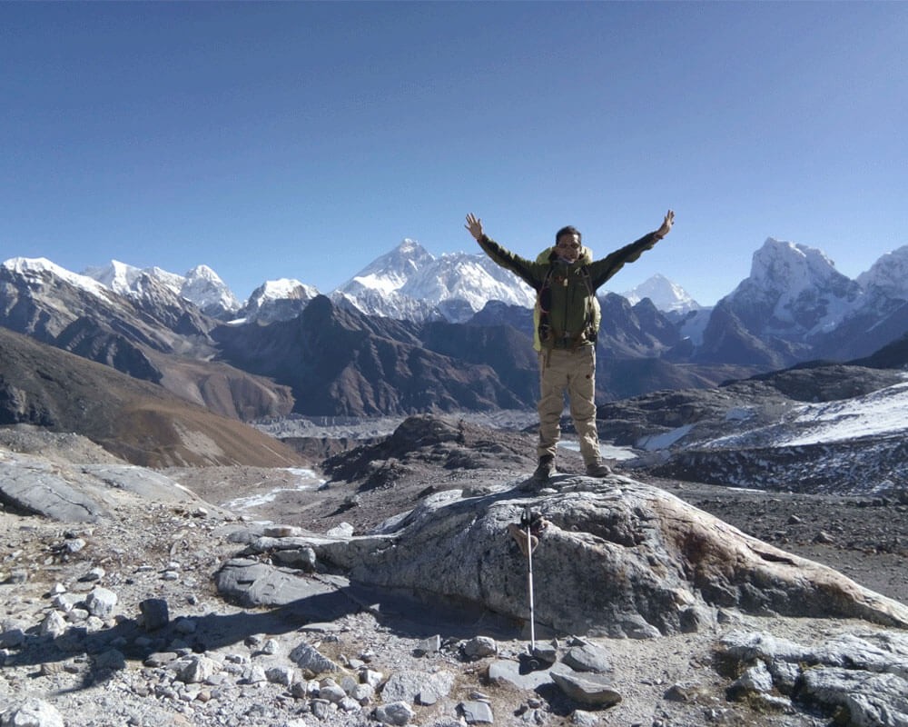
The Manaslu Tsum valley, although a barely touched travel destination, is a worthy destination. The trek will take about 21 days and be quite a long journey. It might be exhausting and difficult at parts like the Larkey La peak, but the views from there will make it worth it. Most of the travel will be very enjoyable despite the long walk hours.
We at [redacted] have a fully furnished itinerary to save you from the trouble of navigating the route to this trekking destination. The total cost of the travel will amount to USD 1575. Contact us for further queries.